May 6 2025 – Marampata to Choquequirao to Marampata
Woke up around 5:30AM today well rested. Breakfast was at 7, then packed up and headed off to Choquequirao.

Marampata and Choquequirao are at the same elevation, but the trail between them does a surprising amount of up and down and up and down. The elderly gentleman from the UK that I met last night started growing concerned that we had gotten on the wrong trail after we had gone down a surprising distance, but there’s only one trail, and as soon as we went around a bend it started going back up again.
After about 90 minutes of hiking you can start to see the site, although it was very cloudy so you could only get glimpses through the clouds.

Eventually the trail crosses a stream that has a waterfall both above and below it, and you round into Choquequirao proper. There are multiple trails through the site. I headed to the campground, which is on a lone terrace tucked into the jungle, and set up my tent and dropped off my pack. There was an employee there, for lack of another term to call him, monitoring the campground. There was definitely a language barrier, but every interaction I had with him left me feeling like he was mad at me for some reason.
From the campground I headed off to explore the ruins. Nearly everyone else that I had met last night had taken an upper path to the upper ruins first, whereas I went down the lower path to the lower ruins first.

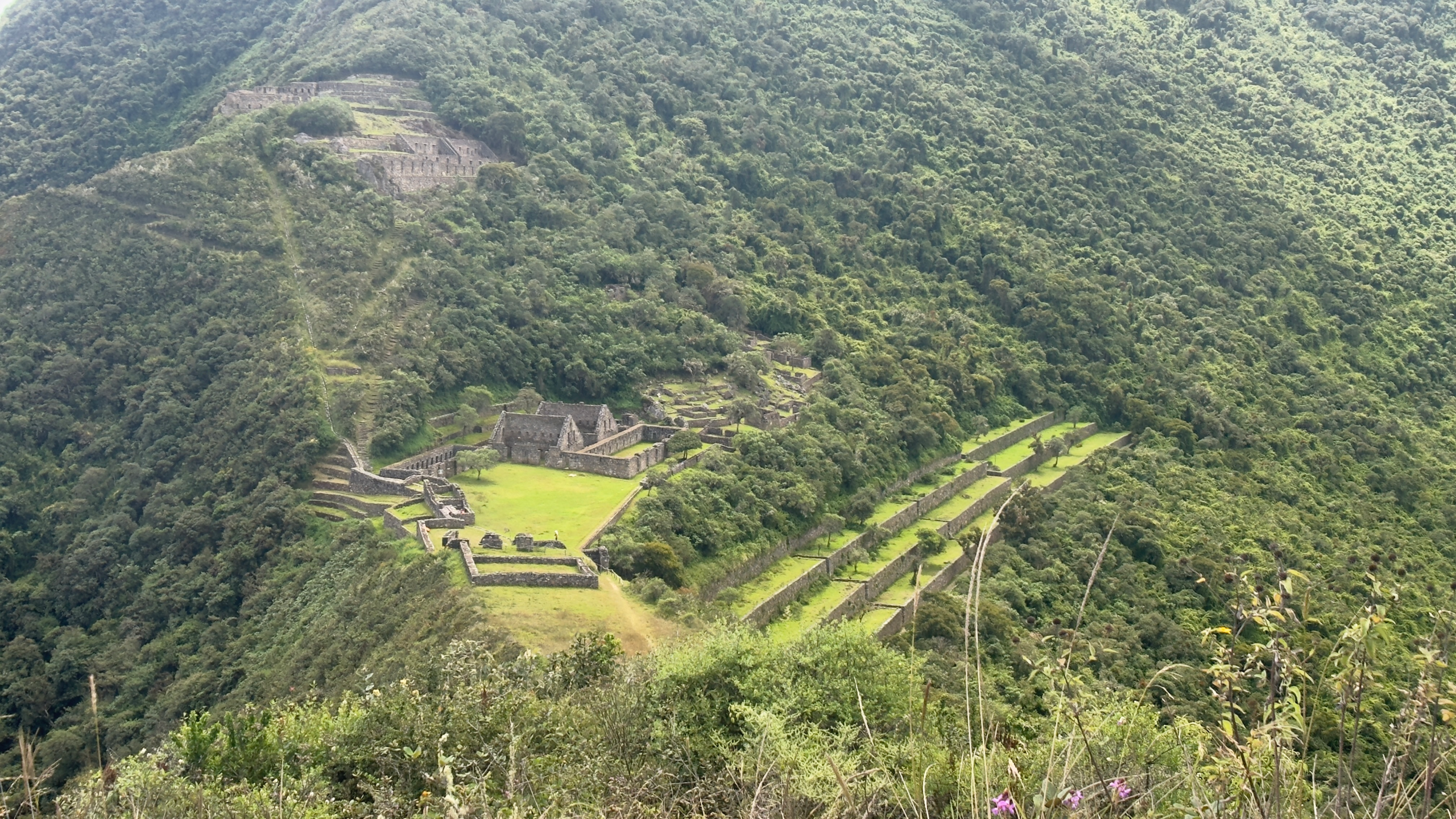
The first area I explored is known as Piquiwasi, or Sector IX B. It’s mostly scattered buildings poking out of the jungle.

From there I made my way out to a knife-edge ridge at the far end of the site, where the House of the Priest is located. I don’t know if that’s actually where any priest lived. I think a lot of names of Incan places are based upon assumptions.
From there the trail heads up to a peak on the ridge that the Inca had completely leveled off. It makes for an excellent viewing platform for the rest of the site.

From there I headed down into the main plaza area.


From the main Plaza I headed down the west side of the mountain. There’s a terrace system there that is unique in all Incan sites. They’re called the Llama Terraces, named such because they’re decorated with figures of Llamas embedded into the rocks.


The Llama terraces are not fully excavated. They go off into the jungle going both directions, so who knows what symbols are yet undiscovered. Also I didn’t get a closeup picture of it, but the bottom terrace has the figure of a man, which is assumed to be a shepherd. Though I did hear a theory that if you draw a line between the man and the “V” figures and continue off into the sky it intersects with heavenly alignments of interest to the Inca. I haven’t seen anything written about that though, so I don’t know how true it is.
From here I took the steep climb back up. Took me an hour to get back to the main plaza, and from there I headed up to the upper sector. The upper sector is also where the trail I was going to be heading out on tomorrow is, so I decided to scope that out. It was incredibly muddy, overgrown, and slippery. I ended up slipping and falling about 8 feet down the slope and bashing my camera against a rock. Shattered my filter stack, so I put my camera away and didn’t end up taking pictures of the upper sector. I also decided that if that had been my head instead of my camera my corpse would be laying in the jungle. So, I’m making the safety call to turn around. I’ll find another way to Machu Picchu.

One of the nice things about turning around is spending another night in Marampata. Worth it.

Tomorrow I’ll head back towards Capuliyoc. Most of my new friends here are planning to try to make it in one day. I’m not in it to win it like that, so I’ll probably spend tomorrow night in Chiquisca.
